

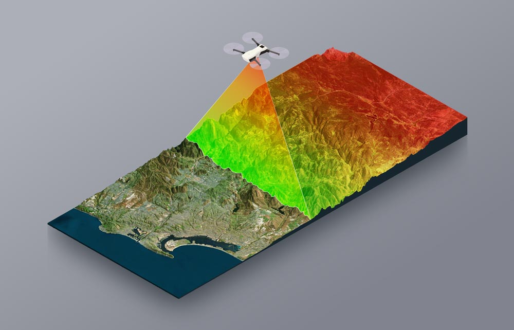
Drone LiDAR combines the ability of drones with the precision of LiDAR technology, enabling detailed and efficient 3D mapping from the air.
This powerful combination allows for rapid data collection in hard-to-reach or hazardous areas, making it invaluable for agriculture, urban planning, and environmental monitoring industries.
By using drone LiDAR, professionals can obtain highly accurate topographic information quickly and cost-effectively.
What is LiDAR Technology?
LiDAR stands for Light Detection and Ranging. It is a remote sensing method that uses laser light to measure distances to the Earth’s surface. By sending out thousands of laser pulses per second and measuring the time it takes for them to return after hitting an object, LiDAR creates detailed, 3D maps of the environment. This technology helps us understand and visualize the world with great precision.
How does LiDAR work?
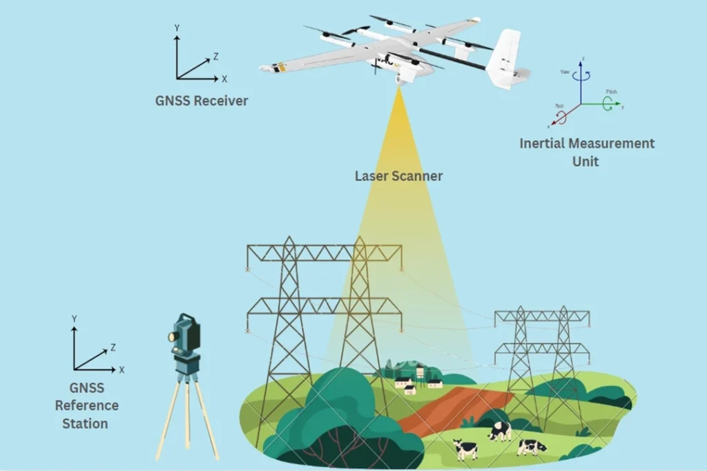
LiDAR emits rapid laser pulses from a sensor, usually mounted on a drone, airplane, or ground-based system. These pulses travel to the ground, bounce off objects like trees, buildings, or the ground itself, and return to the sensor. The system measures the time it takes for each pulse to return. Using this time, the distance to the object can be calculated, creating a detailed 3D map of the area.
History and Development of LiDAR Technology
LiDAR technology has been around since the 1960s. Initially, it was developed for meteorology to measure cloud heights and atmospheric conditions. Over the decades, advances in laser and computing technology have made LiDAR more accurate and affordable.
Comparison with Other Remote Sensing Technologies
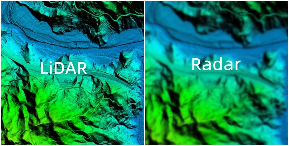
LiDAR vs. Radar
- Radar (Radio Detection and Ranging) uses radio waves instead of laser light to detect objects. Radar is excellent for detecting objects at longer ranges and through obstacles like clouds and fog, but it generally provides less detailed images compared to LiDAR.
LiDAR vs. Photogrammetry
- Photogrammetry involves taking multiple photographs from different angles and using software to create 3D models. While photogrammetry is good for capturing color and texture, LiDAR excels in providing highly accurate distance measurements and detailed 3D maps, even in areas with dense vegetation or complex terrains.
A Brief Summary of Drones
Drones are flying devices controlled remotely, used for many tasks like taking photos, delivering packages, and surveying land. They are efficient and can access hard-to-reach areas easily. Drones also collect data quickly, making them valuable for industries such as agriculture, construction, and environmental monitoring.
How Drones Enhance LiDAR Capabilities
Drones have revolutionized the way we use LiDAR technology. By combining the two, we gain significant advantages in data collection and mapping. Here are some key points on how drones enhance LiDAR capabilities:
Advantages of Using Drones for LiDAR Surveys
Drones equipped with LiDAR can fly over an area and collect detailed 3D data quickly and accurately. This combination offers several benefits:
- Flexibility: Drones can easily maneuver in various environments, providing detailed maps from different angles.
- Precision: LiDAR on drones captures highly accurate measurements, even in complex terrains.
- Speed: Drones can cover large areas much faster than ground-based methods.
Cost-Effectiveness and Efficiency
Using drones for LiDAR surveys is both cost-effective and efficient:
- Lower Costs: Operating drones is cheaper than manned aircraft or extensive ground surveys. There’s no need for pilots, fuel, or large crews.
- Time-Saving: Drones can be deployed quickly and complete surveys in a fraction of the time required by traditional methods. This rapid deployment saves time and money, allowing for more frequent and up-to-date data collection.
Accessibility to Hard-to-Reach Areas
Drones can access areas that are difficult or dangerous for humans to reach:
- Rough Terrain: Drones can easily fly over mountains, forests, and other challenging landscapes.
- Hazardous Locations: They can safely survey areas affected by natural disasters, industrial sites, or remote regions without putting human lives at risk.
A LiDAR drone can typically cover an area ranging from a few acres to several square kilometers per flight, depending on the drone’s battery life, speed, altitude, and the LiDAR sensor’s specifications. For example, a high-end LiDAR drone might cover around 100 to 200 acres in a single flight, while more advanced models could survey larger areas more efficiently.
Types of LiDAR Drones
There are several types of LiDAR drones, each designed for specific applications and environments:
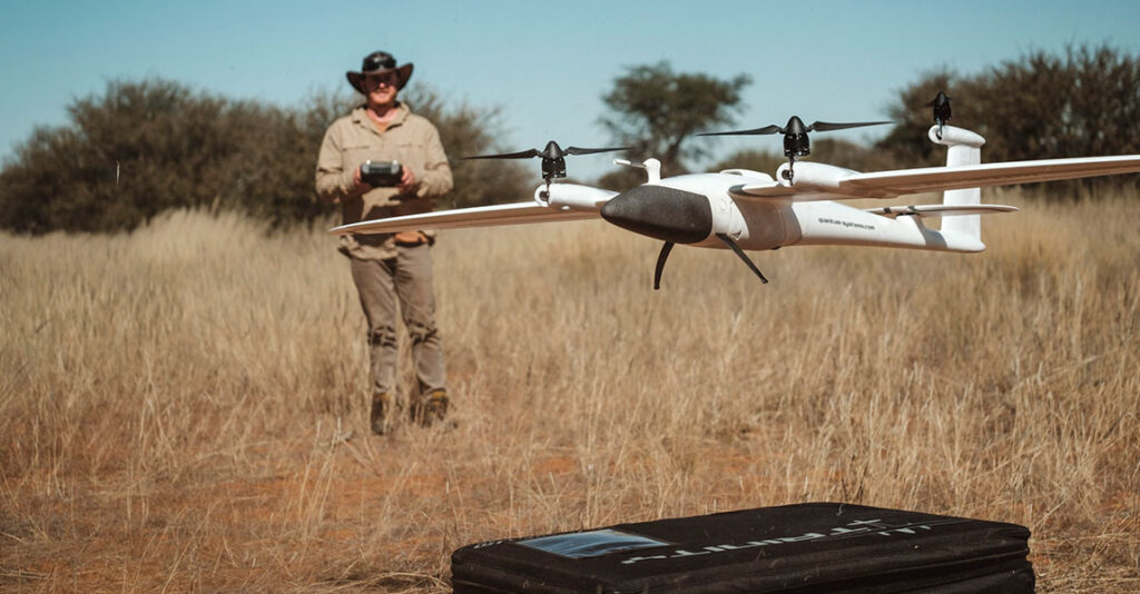
- Fixed-Wing Drones:
- Characteristics: These drones have a rigid wing and fly like airplanes.
- Advantages: They cover large areas quickly and are suitable for long-distance surveys.
- Use Cases: Ideal for mapping large agricultural fields, forests, and expansive landscapes.
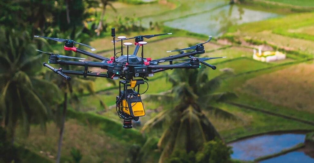
- Multirotor Drones:
- Characteristics: These drones have multiple rotors (usually four or more) and can hover in place.
- Advantages: They provide high maneuverability and stability, making them suitable for detailed surveys in smaller areas.
- Use Cases: Perfect for urban planning, infrastructure inspection, and small to medium-sized areas.
- Hybrid Drones:
- Characteristics: These drones combine features of both fixed-wing and multirotor drones.
- Advantages: They offer a range of fixed-wing drones and the precision of multirotor drones.
- Use Cases: Useful for varied terrain and applications requiring both wide coverage and detailed mapping.
In summary, the area a LiDAR drone can cover depends on its specifications, and there are different types of LiDAR drones designed for various surveying needs.
Applications of Drone LiDAR: Environmental Monitoring and Conservation
Drone LiDAR technology plays a crucial role in environmental monitoring and conservation efforts. Here’s how:
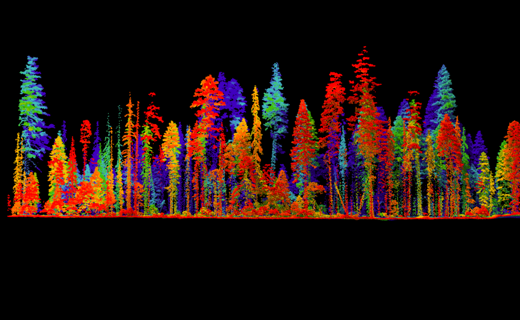
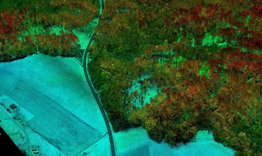
Forest Management:
Drones with LiDAR can create detailed 3D maps of forests, allowing for precise monitoring of tree health, density, and growth patterns. This helps in tracking changes over time and assessing the impact of environmental policies.
LiDAR data helps identify areas affected by deforestation, enabling quick action to protect endangered ecosystems.
Habitat Analysis:
By mapping terrain features and vegetation, LiDAR drones help in identifying and preserving critical wildlife habitats. This data is vital for creating effective conservation plans.
Researchers use LiDAR to study plant and animal diversity, understanding how different species interact with their environment.
Coastal and Marine Conservation:
LiDAR drones map coastal areas, monitoring erosion, and changes in shoreline structure. This information is essential for protecting coastal ecosystems and managing human activities.
Underwater LiDAR systems, sometimes mounted on drones, can map coral reefs, assessing their health and detecting signs of bleaching or damage.
Wetland Management:
LiDAR data helps in understanding water flow patterns in wetlands, essential for maintaining these vital ecosystems. It assists in floodplain mapping and water resource management.
Detailed maps of wetland vegetation help in monitoring plant species and their distribution, which is crucial for wetland conservation.
Disaster Response and Recovery:
After events like hurricanes, earthquakes, or floods, LiDAR drones quickly assess the extent of damage, providing critical information for disaster response and recovery efforts.
Monitoring areas prone to erosion helps in taking preventive measures to protect the environment and nearby human settlements.
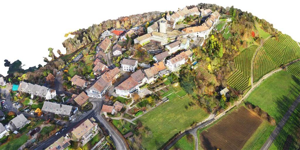
Urban Planning and Infrastructure Management
Drone LiDAR technology is incredibly useful in urban planning and managing infrastructure. It helps city planners and engineers create detailed 3D maps of urban areas, which are essential for designing and developing cities.
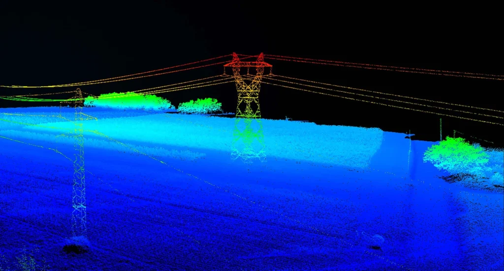
- In urban planning, LiDAR drones provide accurate information about the layout of buildings, roads, and other structures. This data helps planners understand the existing infrastructure and identify areas for new developments.
- For infrastructure management, drone LiDAR is used to inspect and monitor bridges, roads, and buildings. It helps detect structural issues, such as cracks or weaknesses, that might not be visible to the naked eye. This allows for timely maintenance and repairs, ensuring the safety and longevity of these structures.
Drone LiDAR in Agriculture and Forestry
Drone LiDAR technology is transforming the fields of agriculture and forestry by providing detailed, accurate data that helps in better management and decision-making.
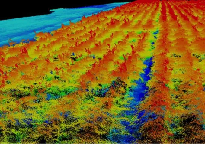
In agriculture, LiDAR drones are used to monitor crop health and growth. They can create precise 3D maps of fields, showing variations in terrain and plant height. This information helps farmers identify areas that need more attention, such as sections that require additional water, fertilizer, or pest control. By using LiDAR data, farmers can optimize their use of resources, leading to healthier crops and higher yields.
LiDAR drones also assist in planning and managing irrigation systems. By mapping the topography of a field, they help design efficient irrigation plans that ensure water reaches all parts of the field evenly. This reduces water waste and ensures that crops get the moisture they need.
Applications of Drone LiDAR in Mining and Geology
Drone LiDAR technology is highly valuable in the fields of mining and geology, providing detailed and accurate data that improves efficiency and safety.
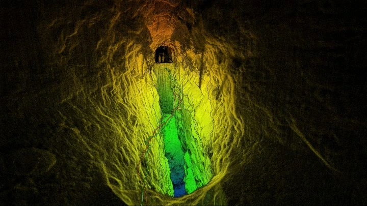
Overall, drone LiDAR technology enhances mining and geology by providing precise, detailed data for site planning, monitoring, and analysis. It improves safety, efficiency, and resource management, making it an invaluable tool in these fields.
Drone LiDAR in Disaster Management and Emergency Response
Drone LiDAR technology has emerged as a powerful tool in disaster management and emergency response. By providing high-resolution, real-time data, Drone LiDAR enables rapid assessment and decision-making during critical situations. This technology offers significant advantages over traditional methods, including enhanced accuracy, speed, and the ability to access hard-to-reach areas.
1. Rapid Assessment and Damage Evaluation
One of the most crucial applications of Drone LiDAR in disaster management is the rapid assessment of affected areas. After a natural disaster such as an earthquake, hurricane, or flood, time is of the essence. Drones equipped with LiDAR sensors can quickly fly over the disaster zone, capturing detailed topographical data and creating accurate 3D maps. This helps emergency responders to evaluate the extent of the damage, identify the most affected areas, and prioritize rescue operations.
2. Search and Rescue Operations
Drone LiDAR plays a vital role in search and rescue missions. In scenarios where visibility is poor or the terrain is difficult to navigate, such as in dense forests, mountainous regions, or collapsed buildings, LiDAR can penetrate through obstacles and provide clear images of the ground below. This allows rescue teams to locate survivors more efficiently and safely, reducing the time taken to reach and save lives.
3. Infrastructure Inspection and Monitoring
After a disaster, it is essential to assess the structural integrity of critical infrastructure, including bridges, roads, and buildings. Drone LiDAR can quickly survey these structures, detecting damages that are not visible to the naked eye. This data is crucial for determining whether infrastructure can be safely used or needs immediate repair, thereby preventing further accidents and ensuring the safety of the population.
4. Flood Risk Management
LiDAR technology is highly effective in flood risk management. Drones can be deployed to map riverbanks, floodplains, and drainage systems before and after a flood event. By analyzing the LiDAR data, authorities can identify changes in the landscape, such as erosion or sediment deposition, and predict future flood risks. This information is invaluable for developing flood mitigation strategies and improving the design of flood defenses.
5. Environmental Monitoring and Recovery
In the aftermath of a disaster, environmental monitoring is critical for assessing the impact on ecosystems and planning recovery efforts. Drone LiDAR can provide detailed information on vegetation cover, soil erosion, and changes in land use. This data helps environmental scientists and policymakers to develop restoration plans, monitor the recovery of natural habitats, and ensure that rebuilding efforts do not further harm the environment.
6. Disaster Preparedness and Planning
Beyond the immediate response, Drone LiDAR is also useful in disaster preparedness and planning. By regularly surveying areas prone to natural disasters, authorities can create detailed risk maps and simulate potential disaster scenarios. This proactive approach enables better planning and resource allocation, enhancing the resilience of communities against future disasters.
How to Collect Data from LiDAR Drones
Collecting data from LiDAR drones involves several steps, from planning the mission to processing and analyzing the data. Here’s a detailed guide on how to effectively collect data using a LiDAR-equipped drone:
1. Pre-Flight Planning
Before launching the drone, clearly define the objectives of the data collection mission. This includes understanding the area to be surveyed, the type of data required (e.g., topographical maps, vegetation analysis), and the specific use case (e.g., disaster assessment, infrastructure inspection).
Choose a drone and LiDAR sensor that matches the mission requirements. Factors to consider include the range and resolution of the LiDAR sensor, the flight time of the drone, and the compatibility between the drone and the sensor.
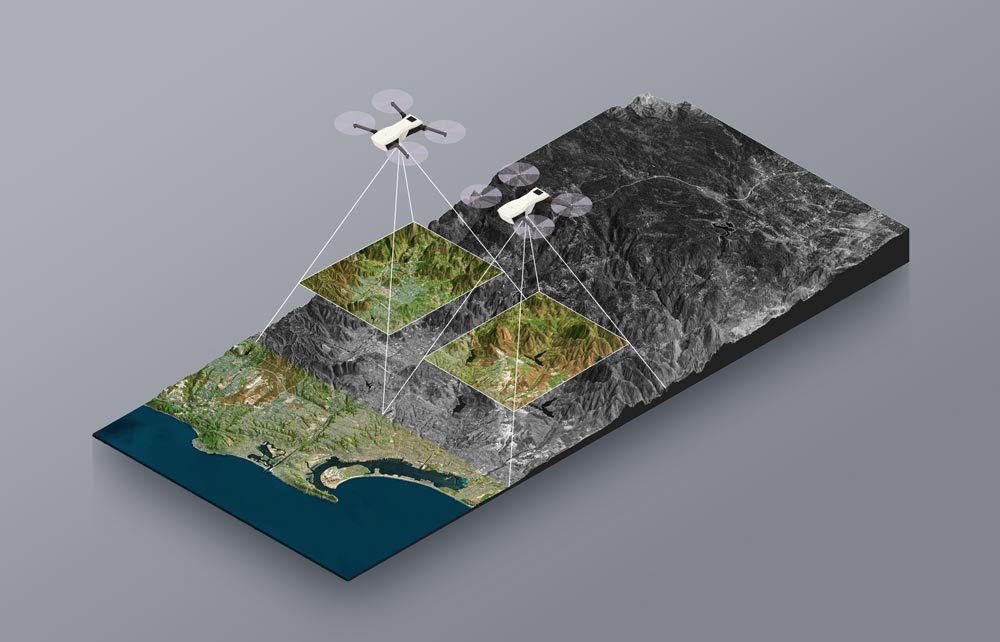
Using mission planning software, design a flight path that covers the entire area of interest. Consider factors such as:
- Altitude: Higher altitudes cover larger areas but with lower resolution; lower altitudes provide higher resolution but cover smaller areas.
- Overlap: Ensure sufficient overlap between flight lines to avoid gaps in data.
- Speed: Adjust the drone speed based on the sensor’s data capture rate to ensure high-quality data.
Check weather conditions and ensure they are suitable for flying. Avoid strong winds, heavy rain, or fog, as these can affect the drone’s stability and the accuracy of the LiDAR data.
2. Conducting the Flight
Perform pre-flight checks to ensure the drone and LiDAR sensor are functioning correctly. This includes:
- Checking battery levels.
- Ensuring the LiDAR sensor is calibrated.
- Verifying GPS accuracy.
- Inspecting the drone for any physical damage.
Launch the drone and monitor the flight in real time using the ground control station. Ensure the drone follows the planned flight path and adjust if necessary. Keep an eye on battery levels and be prepared for an emergency landing if needed.
3. Data Collection
As the drone flies, the LiDAR sensor continuously emits laser pulses and measures the time it takes for the pulses to return after hitting an object. This data is captured and stored on the drone’s onboard storage or transmitted to the ground control station in real time.
Monitor the quality of the data being collected. Look for any anomalies or gaps in the data that may indicate issues with the sensor or flight path. Make adjustments as needed to ensure comprehensive data coverage.
4. Post-Flight Data Processing
After the flight, download the collected LiDAR data from the drone. Organize the data files and back them up to prevent loss.
Pre-process the raw LiDAR data to filter out noise and correct any errors. This involves:
- Georeferencing: Aligning the data with GPS coordinates to ensure accurate spatial representation.
- Noise Filtering: Removing any erroneous data points caused by reflections from dust, birds, or other objects.
- Point Cloud Generation: Converting the LiDAR data into a point cloud format, which represents the 3D structure of the surveyed area.
Use specialized software to analyze the processed LiDAR data. This can include creating 3D models, topographical maps, and other visualizations. Key analysis tasks might involve:
- Classifying Points: Distinguishing between ground, vegetation, buildings, and other objects in the point cloud.
- Measuring Distances and Volumes: Calculating distances between objects and volumes of features like buildings or natural formations.
- Change Detection: Comparing the new data with previous surveys to identify changes in the landscape or infrastructure.
5. Data Interpretation and Reporting
Interpret the analyzed data to derive meaningful insights based on the mission objectives. This could involve identifying damaged areas in a disaster zone, assessing the health of vegetation, or evaluating the structural integrity of infrastructure.
Generate reports and visualizations that communicate the findings clearly to stakeholders. This can include:
- 3D Models and Maps: Detailed visual representations of the surveyed area.
- Statistical Reports: Quantitative analysis of key metrics.
- Infographics: Simplified visual summaries for quick understanding.
6. Archiving and Future Use
Ensure the collected and processed data is stored securely for future reference. This includes maintaining backups and using secure storage solutions.
Use insights gained from the current survey to plan future data collection missions. Continuous monitoring and data collection can help in long-term projects like environmental monitoring, urban planning, and infrastructure maintenance.
Disadvantages of Lidar Drone Technology
While Drone LiDAR (Light Detection and Ranging) technology offers numerous advantages in data collection and analysis, there are also several disadvantages and limitations to consider:
1. High Cost
- Equipment Expense: LiDAR sensors and high-quality drones are expensive. The cost of purchasing and maintaining this equipment can be prohibitive for some organizations.
- Operational Costs: Operating drones equipped with LiDAR involves additional expenses, including training, software, and potential licensing fees.
2. Complex Data Processing
- Technical Expertise Required: Processing and analyzing LiDAR data requires specialized knowledge and skills. This may necessitate hiring trained personnel or investing in training for existing staff.
- Software and Hardware Requirements: High-performance computers and specialized software are needed to process large volumes of LiDAR data, adding to the overall cost and complexity.
3. Limited Flight Time and Range
- Battery Life: Most drones have limited battery life, which restricts the duration and range of LiDAR data collection missions. This can be a significant limitation for surveying large areas.
- Range Limitations: The effective range of the drone’s remote control can also limit the area that can be surveyed in a single flight.
4. Environmental Constraints
- Weather Dependence: Adverse weather conditions such as strong winds, rain, fog, and snow can affect the drone’s flight stability and the accuracy of LiDAR data.
- Light and Shadow: Variations in light and shadow, especially in densely vegetated or urban areas, can impact the quality of the LiDAR data.
5. Regulatory Challenges
- Airspace Regulations: Operating drones, particularly in urban or restricted areas, can be subject to stringent regulations and require special permits.
- Safety Concerns: Ensuring the safety of drone flight, especially in populated areas, is critical and can limit where and when drones can be used.
6. Data Limitations
- Surface Penetration: While LiDAR is excellent for mapping the surface of the Earth, it has limitations in penetrating dense vegetation or water bodies.
- Data Volume: LiDAR generates large volumes of data, which can be challenging to store, manage, and process efficiently.
7. Operational Risks
- Risk of Damage or Loss: Drones are susceptible to crashes, especially in challenging environments, leading to potential loss or damage to expensive equipment.
- Interference: Electromagnetic interference from power lines, buildings, or other sources can affect the performance of the drone and the LiDAR sensor.
When Drone LiDAR Technology and Photogrammetry Replace Each Other?
LiDAR and photogrammetry are both valuable technologies for mapping and surveying, but they have distinct applications and strengths.
While LiDAR offers significant advantages in specific applications, photogrammetry remains valuable for its cost-effectiveness, ease of use, and ability to provide detailed visual imagery. The choice between these technologies depends on the specific requirements of the project, and in many cases, they can be complementary rather than competitive.